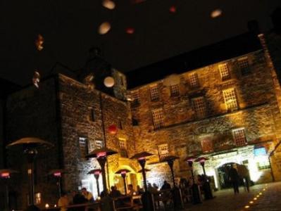
Tailors Hall Hotel Edinburgh (Edinburgh)
- Tailors Hall Hotel Edinburgh (Edinburgh)
-
Tailors Hall Hotel Edinburgh
country: United Kingdom, city: Edinburgh (City: Cowgate)
Tailors Hall Hotel Edinburgh 
Location
The Tailors Hall Hotel Edinburgh is situated in the Cowgate, an extension of the Grassmarket and is only a few minutes walk from the Royal Mile.
Rooms
All the hotel's 42 guestrooms are modern in decor with light wood furnishings and possess a wide range of standard facilities to provide you maximum comfort during your stay.
Restaurant
Guests can relish a variety of local specials served at the onsite restaurant and at the alfresco courtyard. You can also unwind after a tiring day at the hotel bar in an exciting atmosphere.
General
The universal appeal of Tailors Hall Hotel also organizes themed events and outside disco for the you to indulge in.
| Hotel Facilities: | Room Facilities: |
|---|
Cocktail bar
Lobby
Reception
Restaurant | Hairdryer
Iron and ironing board
Pay-per-view movies
Private bathroom / Ensuite
Tea and coffee making facilities
Telephone
Television |
Extra Information:
Address:
139 Cowgate
Edinburgh EH11JS
Scotland
International hotels. — Academic.
2010.
Look at other dictionaries:
Edinburgh (United Kingdom) — Hotels: Apex City Hotel Edinburgh (City: Grassmarket) Apex European Hotel Edinburgh (City: Haymarket) Apex International Hotel Edinburgh (City: Grassmarket) Balmoral Hotel Edinburgh (Lothian) … International hotels
Edinburgh — EDINBURGH, a city, the seat of a university, and the metropolis of the kingdom of Scotland, situated in longitude 3° 10 30 (W.), and latitude 55° 57 29 (N.), about a mile (S. by W.) from Leith, 40 miles (S.S.W.) from Dundee, 42 (E. by N.) from … A Topographical dictionary of Scotland
Glasgow — GLASGOW, a city, the seat of a university, and a sea port, having separate jurisdiction, locally in the Lower ward of the county of Lanark, and situated in longitude 4° 15 51 (W.), and latitude 55° 52 10 (N.), 23 miles (E. by S.) from Greenock … A Topographical dictionary of Scotland
Dunlop, East Ayrshire — Coordinates: 55°42′N 4°32′W / 55.7°N 4.54°W / 55.7; 4.54 … Wikipedia
Dunfermline — DUNFERMLINE, a royal burgh, and parish, in the district of Dunfermline, county of Fife; including the villages of Charlestown, Crossford, Halbeath, Limekilns, Mastertown, Patiemuir, North Queensferry, and part of Crossgates; and containing… … A Topographical dictionary of Scotland
Leith — LEITH, a burgh and sea port town, in the county of Edinburgh, 1½ mile (N. by E.) from Edinburgh, and 392 (N. N. W.) from London; containing, with the parishes of North and South Leith, 28,268 inhabitants. This place, which is of considerable… … A Topographical dictionary of Scotland
Stirling — Observe. Reverse. Ancient Burgh Seal. STIRLING, a royal burgh, sea port, and parish, mostly in the county Stirling; containing, with the villages of Cambuskenneth, Raploch, and part of Causeway head, 9095 inhabitants, of whom 8307 are… … A Topographical dictionary of Scotland
Inverness — INVERNESS, a royal burgh, sea port town, and parish, in the county of Inverness, of which it is the chief town, 156 miles (N. N. W.) from Edinburgh; containing, with the villages of Balloch, Clachnaharry, Culcaboch, Hilton, Resawrie, and… … A Topographical dictionary of Scotland
Lanark — LANARK, a burgh, market town, and parish, in the Upper ward of the county of Lanark; containing, with the villages of Cartland and New Lanark. 7679 inhabitants, of whom 4831 are within the burgh, 25 miles (S. E.) from Glasgow, and 32 (S. W. by … A Topographical dictionary of Scotland

